home
Kīlauea LiDAR
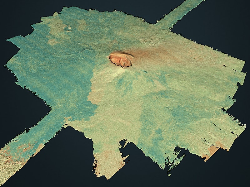
During the current eruption event at Kīlauea there have been numerous collections of Light Detection and Ranging (LiDAR) data in support of ongoing emergency operations. In addition, there are data sets collected in the past that are available here.
- July 2018 - Aerial LiDAR scanning (Summit, Pu’u ‘Ō’ō, LERZ) by CRREL/NCALM /USGS
- June 2018 - Aerial LiDAR scanning by USGS/QuantumSpatial/GEO1
- 2012/2013 - Terrrestrial LiDAR of Kīlauea Summit by CRREL
- 2009 - Aerial LiDAR of Kīlauea summit by NCALM
Contact
-
Please contact Ken Hudnut for program information.
-
Please contact Adam Lewinter for technical information.
View
Data
Data
July 2018 CRREL Helipod Acquisition
0.5m GeoTIFF Filled DTM
Download Summit 0.5m GeoTIFF (filled)
Download Summit 0.5 GeoTIFF RII (Relative Intensity Image)
Download Puna Lerz 0.5 GeoTIFF (filled)
Download Puna Lerz 0.5 GeoTIFF RII (Relative Intensity Image)
S3 path: s3://grid-partner-share/USGS_2018_Kilauea/summit-dtm
S3 path: s3://grid-partner-share/USGS_2018_Kilauea/lerz-dtms
0.5m GeoTIFF DTM
Download Summit 0.5m GeoTIFF (non-filled)
Download Puna Lerz 0.5 GeoTIFF (non-filled)
July 2018 CRREL Helipod Aerial LiDAR as 1km LAZ tiles
(Ground and Noise classified)
Summit S3 path: s3://grid-partner-share/USGS_2018_Kilauea/summit-tiles/
Puna Lerz S3 path: s3://grid-partner-share/USGS_2018_Kilauea/puna-lerz-tiles/
July 2018 CRREL Helipod Aerial LiDAR in flight line configuration
Summit S3 path: s3://grid-partner-share/USGS_2018_Kilauea/summit/
Punz Lerz S3 path s3://grid-partner-share/USGS_2018_Kilauea/Puna_LERZ/
June 2018 Acquisition
0.5m GeoTIFF Filled DTM
Download 0.5m GeoTIFF (filled)
S3 path: s3://grid-partner-share/USGS_2018_Kilauea/not_loaded/DTM_0.5m
S3 path: s3://grid-partner-share/USGS_2018_Kilauea/not_loaded/DTM_0.5m_filled
June 2018 Aerial LiDAR as 1km LAZ tiles (Ground and Noise classified)
S3 path: s3://grid-partner-share/USGS_2018_Kilauea/PC/Pointclouds/
2009 – 2013 Acquisitions
2009 NCALM Aerial LiDAR
2012 – 2013 CRREL Terrestrial Scans
GRiD
Access to the processed data files can be found using the USACE/NGA GRiD system. A one-time registration and login is required. GRiD supports online processing of LiDAR data.
Processing
The initial georegistered flight line point clouds were delivered to the Cold Regions Research and Engineering Lab (CRREL - David Finnegan/Adam LeWinter) for follow on processing via PDAL using a CRREL Amazon cloud instance developed by Hobu Inc under contract to CRREL.
Details
All processing done with PDAL 1.7.2 and GDAL 2.2.0
-
Creation of 1km Tiles from flightlines. All flightlines were read to create a large virtual dataset and then filters.splitter was used to create 1km tiles.
-
Bare earth and noise processing. PDAL filters.outlier in default statistical mode was used to mark points as noise (Classification 7) and then non noise points were passed to filters.smrf (using defaults) and used to mark ground points using Classification 2.
-
Tiles were filtered on Classification 2 points and passed to the gdal writer using IDW (inverse distance weighting) to create DTMs with 1/2 m cell sizes
-
All DTM tiles were merged to 1 geotiff using GDAL 2.2 and written in compressed (LZW) and uncompressed format using Cloud Optimized GeoTIFF (COG) structure. A hillshade in compressed (LZW) and uncompressed was also made.
-
All DTM tiles were then processed using
gdal_fillnodata.pyto create filled DTMs. These were then merged in a similar fashion as in step 4. -
Coordinate system was set to
EPSG:6635+5703
Metadata
Coordinate system information
Aerial data
NAD83 UTM 5N, NAVD88 Geoid 09
TLS data
NAD83(PA11) UTM 5N
Credits
Credits
July Aerial Data
The July 2018 LiDAR data Collection over the Kīlauea Summit and the Lower East Rift Zone was conducted by the US Army Cold Regions Research & Engineering Lab (CRREL), The University of Houston and the USGS. Funding was provided by the State of Hawaii and the Federal Emergency Management Agency (FEMA). The system utilized was an R44 helicopter based pod which uses a Riegl VQ580i full waveform laser scanner. Total of 9 flights over the course of 5 days (July 8 - 12, 2018)
June 2018 Aerial Data
This data set was contracted by the USGS via Quantum Spatial, Inc., and acquired by GEO1 and Windward Aviation. GEO1 conducted the collection activity using a Windward Aviation Hughes 500 helicopter with a dual LiDAR scanning system that utilized two Riegl VUX-SYS scanners operated as one unit. The data set was acquired through 11 lifts, and comprises 4 distinct AOIs.
2012 – 2013 CRREL Terrestrial Scans
The 2012 - 2013 terrestrial LiDAR data collection over Kilauea’s Halema’uma’u Crater and Overlook lava lake was conducted by the US Army Cold Regions Research & Engineering Lab (CRREL), the University of Northern Colorado and the USGS Hawaiian Volcano Observatory (HVO). These data were collected using a Riegl VZ-1000 full-waveform laser scanner. The researchers tracked the growth of the Overlook lava lake crater over time and the lava lake surface activity using multi-temporal surveys.
2009 NCALM Aerial LiDAR
NCALM and others. See https://doi.org/10.5069/G9DZ067X for full detail.
 ]
]